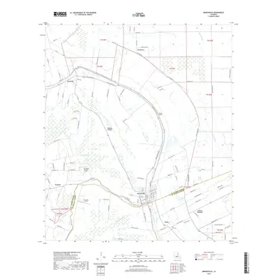
2018 Map of Arnaudville
USGS Topo · Published 2018About this map
Arnaudville straddles the boundary of St. Landry and St. Martin Parishes, situated at the scenic junction of Bayou Teche and Bayou Petit Brule. This Acadiana landscape is defined by its deep French-influenced heritage, seen in the many French-named roads and settlements such as Pecaniere, Frozard, and Pointe Claire. The map reveals a transition from the denser residential grid of Leonville to the sprawling agricultural tracts and wetlands surrounding Bayou Portage and Coulee Lanoire. Small private airfields like the Tim Bullard Memorial Airport and Gouvillion Airport are dotted throughout the rural expanses, while Robin Bridge provides a critical crossing over the Teche. To the southeast, the landscape transitions toward Darby and Coteau Rodaire, where the Ring Zion Cem stands as a focal point for local genealogical research in this long-settled Cajun country.
Find a feature on this map
112 named features on this map. Tap any name to fly to it.
Don’t see what you’re looking for? This feature index may not catch every label — zoom into the map to look around manually.
Map Details
Editions of this 2018 Arnaudville Map
This is the sole edition of this map. No revisions or reprints were ever made.
Other maps of this area

1939 · Opelousas
USGS Topo · 1:62,500

1940 · Arnaudville
USGS Topo · 1:62,500

1952 · Lake Charles
USGS Topo · 1:250,000

1954 · Lake Charles
USGS Topo · 1:250,000

1954 · Baton Rouge
USGS Topo · 1:250,000

1956 · Opelousas
USGS Topo · 1:62,500

1956 · Baton Rouge
USGS Topo · 1:250,000

1957 · Opelousas
USGS Topo · 1:62,500

1957 · Carencro
USGS Topo · 1:62,500

1959 · Palmetto
USGS Topo · 1:62,500