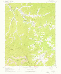
1964 Map of Arnett
USGS Topo · Published 1975About this map
Marsh Fork winds through the heart of this Raleigh County landscape, connecting a string of mid-century coal and timber communities including Naoma, Dry Creek, Rock Creek, and Arnett. The geography is defined by the steep rises of Peachtree Ridge and Locust Ridge, where numerous family cemeteries like Horse Cem, Bone Cem, and Pettry Cem are tucked into the hollows. This 1964 field-checked survey illustrates a transitional Appalachian economy, where traditional landmarks like the Mt View Sch and New Hope Ch stand alongside an increasing industrial footprint. Numerous Gas Wells are scattered across the ridges, and Strip Mines appear near Spring Mountain, marking the intensification of resource extraction. In the southern reach, the Guyandotte River cuts through the terrain near the Raleigh Co Wyoming Co line, while local life centers on crossroads like Bolt and Saxon.
Find a feature on this map
106 named features on this map. Tap any name to fly to it.
Don’t see what you’re looking for? This feature index may not catch every label — zoom into the map to look around manually.
Map Details
Editions of this 1964 Arnett Map
4 editions found
Other maps of this area

1891 · Oceana
USGS Topo · 1:125,000

1891 · Raleigh
USGS Topo · 1:125,000

1893 · Oceana
USGS Topo · 1:125,000

1897 · Raleigh
USGS Topo · 1:125,000

1898 · Oceana
USGS Topo · 1:125,000

1902 · Raleigh
USGS Topo · 1:125,000

1910 · Pineville
USGS Topo · 1:48,000

1910 · Bald Knob
USGS Topo · 1:48,000

1911 · Marshes
USGS Topo · 1:48,000

1912 · Mullens
USGS Topo · 1:62,500