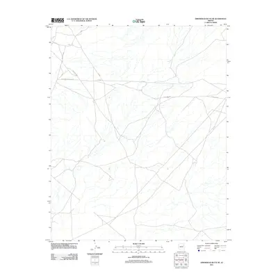
2011 Map of Arrowhead Butte NE
USGS Topo · Published 2011About this map
Trans Western Pipeline Rd cuts across the high desert landscape of Northeast Arizona, serving as a primary corridor through this sparsely populated region. The network of paths and routes, including Indian Rte 9006 and Indian Rte 9606, reveals a system of land management and travel that relies on established tribal and utility thoroughfares. While the terrain is etched with numerous ephemeral drainage channels, the presence of specific markers like N 158 and Rte 9606 provides a framework for navigating the open spaces near the Arrowhead Butte NE quadrangle. The geometry of the roads suggests a landscape organized by both local transit needs and larger industrial infrastructure, as indicated by the prominent pipeline corridor.
Find a feature on this map
7 named features on this map. Tap any name to fly to it.
Don’t see what you’re looking for? This feature index may not catch every label — zoom into the map to look around manually.
Map Details
Editions of this 2011 Arrowhead Butte NE Map
This is the sole edition of this map. No revisions or reprints were ever made.
Other maps of this area

1886 · Fort Defiance
USGS Topo · 1:250,000

1892 · Fort Defiance
USGS Topo · 1:250,000

1954 · Gallup
USGS Topo · 1:250,000

1958 · Gallup
USGS Topo · 1:250,000

1959 · Gallup
USGS Topo · 1:250,000

1962 · Gallup
USGS Topo · 1:250,000

1967 · Gallup
USGS Topo · 1:250,000
1972 · Tanner Springs
USGS Topo · 1:24,000
1972 · Greasewood
USGS Topo · 1:24,000
1972 · Arrowhead Butte
USGS Topo · 1:24,000