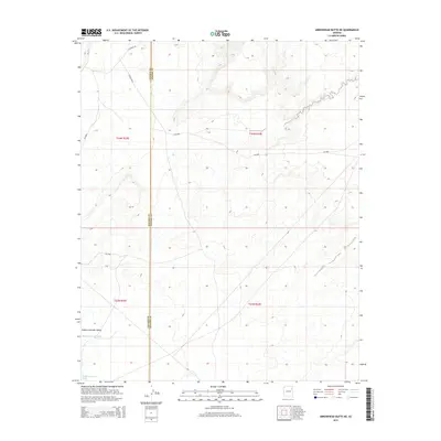
2014 Map of Arrowhead Butte NE
USGS Topo · Published 2014About this map
The Navajo Co Apache Co boundary runs vertically through this 2014 survey, dividing the arid high-desert landscape of northeastern Arizona. This territory is defined by the Pueblo Colorado Valley, where the ephemeral drainage of the Pueblo Colorado Wash cuts through the southwestern portion of the sheet. The map illustrates a sparse, rural infrastructure managed by the Bureau of Indian Affairs and local counties, with routes such as Bia-9606 and Co Road 158 providing the primary access through the open range. The survey depicts a landscape of subtle topographical variations and intermittent watercourses typical of the region, emphasizing the vast distances between named landmarks and modern road systems like Bia-157 and Co Road 9003.
Find a feature on this map
12 named features on this map. Tap any name to fly to it.
Don’t see what you’re looking for? This feature index may not catch every label — zoom into the map to look around manually.
Map Details
Editions of this 2014 Arrowhead Butte NE Map
This is the sole edition of this map. No revisions or reprints were ever made.
Other maps of this area

1886 · Fort Defiance
USGS Topo · 1:250,000

1892 · Fort Defiance
USGS Topo · 1:250,000

1954 · Gallup
USGS Topo · 1:250,000

1958 · Gallup
USGS Topo · 1:250,000

1959 · Gallup
USGS Topo · 1:250,000

1962 · Gallup
USGS Topo · 1:250,000

1967 · Gallup
USGS Topo · 1:250,000
1972 · Tanner Springs
USGS Topo · 1:24,000
1972 · Greasewood
USGS Topo · 1:24,000
1972 · Arrowhead Butte
USGS Topo · 1:24,000