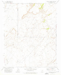
1972 Map of Arrowhead Butte NE
USGS Topo · Published 1976About this map
Mennonite Mission stands as a focal point of settlement in this 1972 survey of the high plateau country within the Navajo Indian Reservation. The terrain is defined by the expansive drainage system of Pueblo Colorado Wash, which meanders across the northwest corner of the map. This area is characterized by an Indefinite Boundary and the jurisdictional line of the Navajo Co Apache Co border. Evidence of modern utility infrastructure appears via a prominent east-west Pipeline, while the presence of a localized Well indicates the critical importance of water management in this arid landscape.
Find a feature on this map
8 named features on this map. Tap any name to fly to it.
Don’t see what you’re looking for? This feature index may not catch every label — zoom into the map to look around manually.
Map Details
Editions of this 1972 Arrowhead Butte NE Map
This is the sole edition of this map. No revisions or reprints were ever made.
Other maps of this area

1886 · Fort Defiance
USGS Topo · 1:250,000

1892 · Fort Defiance
USGS Topo · 1:250,000

1954 · Gallup
USGS Topo · 1:250,000

1958 · Gallup
USGS Topo · 1:250,000

1959 · Gallup
USGS Topo · 1:250,000

1962 · Gallup
USGS Topo · 1:250,000

1967 · Gallup
USGS Topo · 1:250,000
1972 · Tanner Springs
USGS Topo · 1:24,000
1972 · Greasewood
USGS Topo · 1:24,000
1972 · Arrowhead Butte
USGS Topo · 1:24,000