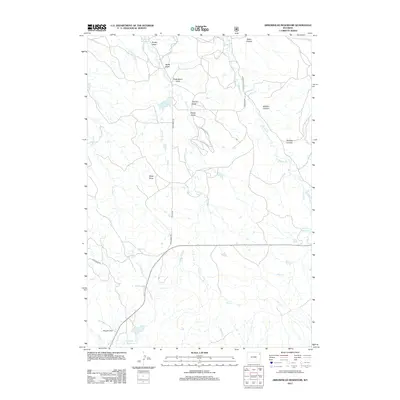
2012 Map of Arrowhead Reservoir
USGS Topo · Published 2012About this map
Arrowhead Reservoir and the surrounding high plains of Crook County are defined by a network of drainage draws and small water catchments essential for ranching. This 2012 survey illustrates the importance of managed water in a semi-arid landscape, featuring Hagerman Reservoir and Upton Reservoir alongside numerous named topographical depressions such as Deep Draw and Fredrickson Draw. The drainage system is complex, with Willow Cr, Arch Cr, and Mason Cr cutting through the terrain towards the larger Sage Cr basin. Access across this landscape is maintained via a grid of rural routes including Arch Creek Rd and Upper Inyan Kara Rd, which connect remote landmarks like Hopper Flat and the deep incisions of Baker Canyon to the wider region.
Find a feature on this map
29 named features on this map. Tap any name to fly to it.
Don’t see what you’re looking for? This feature index may not catch every label — zoom into the map to look around manually.
Map Details
Editions of this 2012 Arrowhead Reservoir Map
This is the sole edition of this map. No revisions or reprints were ever made.
Other maps of this area

1898 · Sundance
USGS Topo · 1:125,000

1902 · Sundance
USGS Topo · 1:125,000

1918 · Moorcroft
USGS Topo · 1:125,000

1954 · Gillette
USGS Topo · 1:250,000

1955 · Gillette
USGS Topo · 1:250,000

1957 · Nefsy Divide
USGS Topo · 1:62,500

1957 · Upton
USGS Topo · 1:62,500

1958 · Gillette
USGS Topo · 1:250,000
1958 · Inyan Kara Mountain
USGS Topo · 1:62,500

1958 · Sundance
USGS Topo · 1:62,500