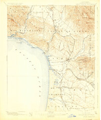
1897 Map of Arroyo Grande
USGS Topo · Published 1925About this map
Coastal San Luis Obispo County unfolds during the late nineteenth century, defined by the meeting of the Southern Pacific R. R. (Coast Line) and the rugged Central Coast. The landscape is a mix of fertile valleys and steep ranges, where the Santa Maria Valley meets the San Luis Range. Resource extraction and early tourism are evident in the presence of Asphalt Mines near Edna and the thermal waters of Sycamore Springs and Newsom Springs.
Find a feature on this map
78 named features on this map. Tap any name to fly to it.
Don’t see what you’re looking for? This feature index may not catch every label — zoom into the map to look around manually.
Map Details
Editions of this 1897 Arroyo Grande Map
5 editions found
Other maps of this area

1897 · Port Harford
USGS Topo · 1:62,500

1897 · San Luis Obispo
USGS Topo · 1:62,500

1897 · Cayucos
USGS Topo · 1:62,500

1897 · Arroyo Grande
USGS Topo · 1:62,500

1900 · San Luis
USGS Topo · 1:125,000

1905 · Guadalupe
USGS Topo · 1:125,000

1905 · Lompoc
USGS Topo · 1:125,000

1922 · Pozo
USGS Topo · 1:62,500

1922 · Nipomo
USGS Topo · 1:62,500

1937 · Cayucos
USGS Topo · 1:62,500