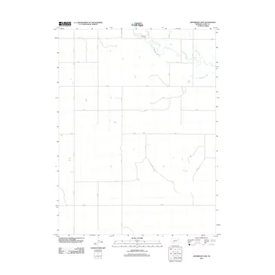
2011 Map of Arterburn Lake
USGS Topo · Published 2011About this map
Arterburn Lake and its corresponding Arterburn Dam serve as the primary landmarks in this section of Chase County, where the high plains landscape is defined by a strictly organized grid of rural roads and water management features. The northern portion of the map reveals the hydrological significance of Frenchman Creek, which is accompanied by the M Abanville Canal, reflecting the region's reliance on irrigation and water control. Other drainage patterns, such as Walnut Slough and McGuires Slough, further illustrate the natural flow and modification of the local watershed. This 2011 survey documents a rural environment where land use is dictated by the section line roads, including 736 Rd and 314 Ave, creating a systematic agricultural layout typical of the Nebraska panhandle and southwest region.
Find a feature on this map
19 named features on this map. Tap any name to fly to it.
Don’t see what you’re looking for? This feature index may not catch every label — zoom into the map to look around manually.
Map Details
Editions of this 2011 Arterburn Lake Map
This is the sole edition of this map. No revisions or reprints were ever made.
Other maps of this area

1954 · Sterling
USGS Topo · 1:250,000

1954 · McCook
USGS Topo · 1:250,000

1957 · McCook
USGS Topo · 1:250,000

1958 · McCook
USGS Topo · 1:250,000

1958 · Sterling
USGS Topo · 1:250,000

1961 · Lamar
USGS Topo · 1:24,000

1971 · Amherst SE
USGS Topo · 1:24,000

1971 · Alvin
USGS Topo · 1:24,000

1971 · Alvin NE
USGS Topo · 1:24,000
1973 · Lamar
USGS Topo · 1:24,000