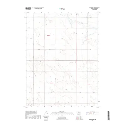
2017 Map of Arterburn Lake
USGS Topo · Published 2017About this map
Arterburn Lake sits near the northern edge of this Chase County landscape, a vital water feature in an area defined by agricultural water management. The drainage and irrigation patterns of the early 21st century are clearly visible through the winding course of Frenchman Cr and the engineered precision of the Maranville Canal. These waterways, along with Walnut Slough and Mcguires Slough, illustrate the critical relationship between the local geography and the high plains water table. The terrain is partitioned by a strictly rectangular grid of rural roads, including 734 Rd and 732 Ave, which delineate the sections of townships t6n r41w and t5n r40w. This grid highlights the systematic land division that has governed Nebraska's ranching and farming operations for generations.
Find a feature on this map
21 named features on this map. Tap any name to fly to it.
Don’t see what you’re looking for? This feature index may not catch every label — zoom into the map to look around manually.
Map Details
Editions of this 2017 Arterburn Lake Map
This is the sole edition of this map. No revisions or reprints were ever made.
Other maps of this area

1954 · Sterling
USGS Topo · 1:250,000

1954 · McCook
USGS Topo · 1:250,000

1957 · McCook
USGS Topo · 1:250,000

1958 · McCook
USGS Topo · 1:250,000

1958 · Sterling
USGS Topo · 1:250,000

1961 · Lamar
USGS Topo · 1:24,000

1971 · Amherst SE
USGS Topo · 1:24,000

1971 · Alvin
USGS Topo · 1:24,000

1971 · Alvin NE
USGS Topo · 1:24,000
1973 · Lamar
USGS Topo · 1:24,000