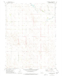
1973 Map of Arterburn Lake
USGS Topo · Published 1977About this map
Frenchman Creek winds through the northern portion of this Chase County landscape, defining a network of hydrology that supported the region's agricultural development in the 1970s. The map illustrates a transition from the natural watercourses of Walth Slough and McGuires Slough to managed irrigation infrastructure, most notably the Maranville Canal. This man-made waterway draws from the creek to feed local land, while the namesake Arterburn Lake sits as a prominent feature in the north-central section.
Find a feature on this map
7 named features on this map. Tap any name to fly to it.
Don’t see what you’re looking for? This feature index may not catch every label — zoom into the map to look around manually.
Map Details
Editions of this 1973 Arterburn Lake Map
This is the sole edition of this map. No revisions or reprints were ever made.
Other maps of this area

1954 · Sterling
USGS Topo · 1:250,000

1954 · McCook
USGS Topo · 1:250,000

1957 · McCook
USGS Topo · 1:250,000

1958 · McCook
USGS Topo · 1:250,000

1958 · Sterling
USGS Topo · 1:250,000

1961 · Lamar
USGS Topo · 1:24,000

1971 · Amherst SE
USGS Topo · 1:24,000

1971 · Alvin
USGS Topo · 1:24,000

1971 · Alvin NE
USGS Topo · 1:24,000
1973 · Lamar
USGS Topo · 1:24,000