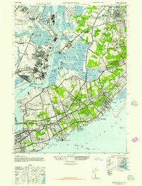
1947 Map of Arthur Kill
USGS Topo · Published 1947About this map
Industrial facilities and social institutions dominate the landscape of Staten Island and the New Jersey shoreline in this post-war Army Map Service study. The Arthur Kill waterway separates the heavy industrial works of Linden and Carteret—including the Standard Oil Co of New Jersey and the American Cyanamide Company—from the developing residential and institutional corridors of Richmond. The map reveals a high concentration of charitable and state facilities, such as the NY State School Mental Defectives, the New York City Farm Colony, and several large orphanages like Mt Loretto Orphanage. The interior remains surprisingly undeveloped, featuring extensive wetlands around Fresh Kills and the rolling grounds of the Latourette Country Club. Traces of earlier industry appear at the Old Brick Kilns and the Kreischer & Sons Brick Co near Kreischerville, highlighting the transition from raw material extraction to a complex suburban and industrial hub.
Find a feature on this map
103 named features on this map. Tap any name to fly to it.
Don’t see what you’re looking for? This feature index may not catch every label — zoom into the map to look around manually.
Map Details
Editions of this 1947 Arthur Kill Map
This is the sole edition of this map. No revisions or reprints were ever made.
Other maps of this area

1888 · Plainfield
USGS Topo · 1:62,500

1888 · New Brunswick
USGS Topo · 1:62,500

1888 · Sandy Hook
USGS Topo · 1:62,500

1893 · New Brunswick
USGS Topo · 1:62,500

1893 · Plainfield
USGS Topo · 1:62,500

1893 · Sandy Hook
USGS Topo · 1:62,500

1898 · Plainfield
USGS Topo · 1:62,500

1898 · Staten Island
USGS Topo · 1:62,500

1900 · Passaic
USGS Topo · 1:125,000

1900 · Staten Island
USGS Topo · 1:62,500