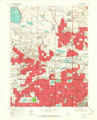
1965 Map of Arvada
USGS Topo · Published 1967About this map
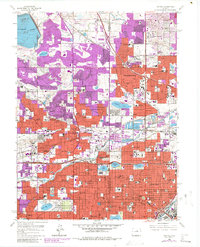
Standley Lake anchors the northwestern corner of this mid-1960s landscape, serving as a primary water source for the burgeoning suburban expansion of Westminster and Arvada. The map illustrates a transitional era where agricultural infrastructure like the Farmers Highline Canal and various irrigation ditches intersect with rapid residential development. This growth is evidenced by the numerous schools and religious institutions established to serve new neighborhoods, including the Shaw Heights Jr High Sch, Holy Trinity Sch, and Baker Sch.
Find a feature on this map
129 named features on this map. Tap any name to fly to it.
Don’t see what you’re looking for? This feature index may not catch every label — zoom into the map to look around manually.
Map Details
Editions of this 1965 Arvada Map
6 editions found
Other maps of this area

1890 · East Denver
USGS Topo · 1:125,000

1899 · West Denver
USGS Topo · 1:125,000

1935 · East Denver Nos. 3 and 4
USGS Topo · 1:48,000

1938 · Morrison
USGS Topo · 1:24,000

1938 · Derby
USGS Topo · 1:24,000

1939 · Golden
USGS Topo · 1:24,000

1940 · Englewood
USGS Topo · 1:31,680

1940 · Eastlake
USGS Topo · 1:31,680

1940 · Lafayette
USGS Topo · 1:31,680

1940 · Derby
USGS Topo · 1:31,680