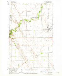
1963 Map of Arvilla
USGS Topo · Published 1965About this map
The Grand Forks Air Force Base dominates the eastern landscape of this early 1960s survey, representing a significant Cold War military footprint in North Dakota. This developed installation stands in sharp contrast to the surrounding agricultural prairie, where the Turtle River meanders through the western half of the quadrangle. Within this riparian corridor, Turtle River State Park preserves the natural bends of the watercourse against the steady grid of field lines.
Find a feature on this map
15 named features on this map. Tap any name to fly to it.
Don’t see what you’re looking for? This feature index may not catch every label — zoom into the map to look around manually.
Map Details
Editions of this 1963 Arvilla Map
This is the sole edition of this map. No revisions or reprints were ever made.
Other maps of this area

1926 · Ardoch
USGS Topo · 1:62,500

1934 · Emerado
USGS Topo · 1:48,000

1936 · Emerado
USGS Topo · 1:62,500

1936 · Larimore
USGS Topo · 1:62,500

1952 · Grand Forks
USGS Topo · 1:250,000

1952 · Thief River Falls
USGS Topo · 1:250,000

1956 · Thief River Falls
USGS Topo · 1:250,000

1956 · Grand Forks
USGS Topo · 1:250,000

1957 · Thief River Falls
USGS Topo · 1:250,000

1963 · Larimore East
USGS Topo · 1:24,000