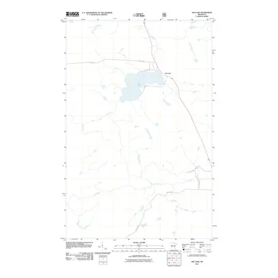
2011 Map of Ash Lake
USGS Topo · Published 2011About this map
Ash Lake and its surrounding wetlands form the center of this northern Minnesota landscape, where the Ash River and Lost River wind through the North Woods. The settlement of Ash Lake sits along the eastern shore, positioned near a network of local forest routes and management paths. The road layout reveals a history of land use and navigation in Saint Louis County, specifically where Ash Lake Rd and Old Ash Lake Rd meet near the water's edge. Further south, the Lost River Management Rd and Town Line Rd indicate the administrative and practical divisions of this remote timber and recreational area. The topography is defined by complex water systems, with numerous unnamed ponds and drainage streams feeding into the primary river corridors.
Find a feature on this map
9 named features on this map. Tap any name to fly to it.
Don’t see what you’re looking for? This feature index may not catch every label — zoom into the map to look around manually.
Map Details
Editions of this 2011 Ash Lake Map
This is the sole edition of this map. No revisions or reprints were ever made.
Other maps of this area

1954 · International Falls
USGS Topo · 1:250,000

1957 · International Falls
USGS Topo · 1:250,000

1958 · International Falls
USGS Topo · 1:250,000

1968 · Ash River SE
USGS Topo · 1:24,000

1968 · Ash Lake
USGS Topo · 1:24,000

1968 · Ash River SW
USGS Topo · 1:24,000
1968 · Orr NE
USGS Topo · 1:24,000

1968 · Orr SW
USGS Topo · 1:24,000
1968 · Orr
USGS Topo · 1:24,000

1969 · Ray SE
USGS Topo · 1:24,000