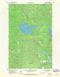
1968 Map of Orr NE
USGS Topo · Published 1971About this map
The Kabetogama State Forest dominates this landscape in northern St. Louis County, where intricate water systems define the geography. Centered on the broad expanse of Black Duck Lake and the nearby Elephant Lake, the area is characterized by low-lying wetlands and connected waterways like the Black Duck River and Lost River. In the southwest corner, the Duluth Winnipeg and Pacific railroad cuts through the terrain, providing a vital industrial link through the township of Leiding. This 1960s survey captures the region's managed wilderness before modern development, notably featuring the Elephant Lake Lookout Tower on a high point overlooking the eastern shoreline. The map also detail the southern drainage of the Pelican River and several smaller basins including South Bog Lake and Chub Lake, illustrating the complex glacial topography of the Minnesota Northwoods.
Find a feature on this map
14 named features on this map. Tap any name to fly to it.
Don’t see what you’re looking for? This feature index may not catch every label — zoom into the map to look around manually.
Map Details
Editions of this 1968 Orr NE Map
2 editions found
Other maps of this area

1954 · International Falls
USGS Topo · 1:250,000

1957 · International Falls
USGS Topo · 1:250,000

1958 · International Falls
USGS Topo · 1:250,000

1967 · Marion Lake
USGS Topo · 1:24,000

1967 · Elephant Lake
USGS Topo · 1:24,000
1968 · Myrtle Lake
USGS Topo · 1:24,000

1968 · Ash River SE
USGS Topo · 1:24,000

1968 · Ash Lake
USGS Topo · 1:24,000

1968 · Ash River SW
USGS Topo · 1:24,000

1968 · Orr SW
USGS Topo · 1:24,000