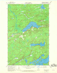
1968 Map of Myrtle Lake
USGS Topo · Published 1969About this map
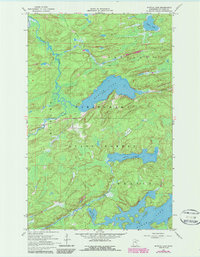
Kabetogama State Forest dominates this northern Minnesota landscape, where the terrain is defined by a dense network of glacial lakes and winding waterways. Centered on the clear waters of Myrtle Lake, the area shows a distinct lack of permanent settlements, focused instead on the natural drainage patterns of the Pelican River. An interpretive look at the map reveals the legacy of the region's timber era, evidenced by the Old Railroad Grade that winds through the northern sections, cutting through the forest toward Clear Lake. To the south, the irregular shoreline of Elbow Lake and the smaller Little Elbow Lake further illustrate the complex hydrology of St. Louis County. These features, along with Ban Lake, represent a wilderness preserved for state management during the late 1960s.
Find a feature on this map
10 named features on this map. Tap any name to fly to it.
Don’t see what you’re looking for? This feature index may not catch every label — zoom into the map to look around manually.
Map Details
Editions of this 1968 Myrtle Lake Map
2 editions found
Other maps of this area

1954 · Hibbing
USGS Topo · 1:250,000

1954 · International Falls
USGS Topo · 1:250,000

1957 · Hibbing
USGS Topo · 1:250,000

1957 · International Falls
USGS Topo · 1:250,000

1958 · International Falls
USGS Topo · 1:250,000

1958 · Hibbing
USGS Topo · 1:250,000

1964 · Hibbing
USGS Topo · 1:250,000

1964 · Haley
USGS Topo · 1:24,000

1964 · Gheen
USGS Topo · 1:24,000
1964 · Norwegian Bay
USGS Topo · 1:24,000