
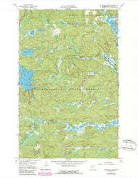
1967 Map of Elephant Lake
USGS Topo · Published 1970About this map
Elephant Lake and the winding Pelican River dominate this wilderness landscape in northern St. Louis County. This 1967 survey reveals a remote pocket of the North Woods where the Superior National Forest meets the Kabetogama State Forest. The geography is defined by a dense network of water, including Silver Lake, Bug Lake, and the northward-flowing Vermilion River.
Find a feature on this map
17 named features on this map. Tap any name to fly to it.
Don’t see what you’re looking for? This feature index may not catch every label — zoom into the map to look around manually.
Map Details
Editions of this 1967 Elephant Lake Map
2 editions found
Other maps of this area

1954 · International Falls
USGS Topo · 1:250,000

1957 · International Falls
USGS Topo · 1:250,000

1958 · International Falls
USGS Topo · 1:250,000

1967 · Kabustasa Lake
USGS Topo · 1:24,000

1967 · Marion Lake
USGS Topo · 1:24,000
1967 · Buyck
USGS Topo · 1:24,000

1967 · Johnson Lake
USGS Topo · 1:24,000
1968 · Myrtle Lake
USGS Topo · 1:24,000

1968 · Ash River SE
USGS Topo · 1:24,000
1968 · Orr NE
USGS Topo · 1:24,000