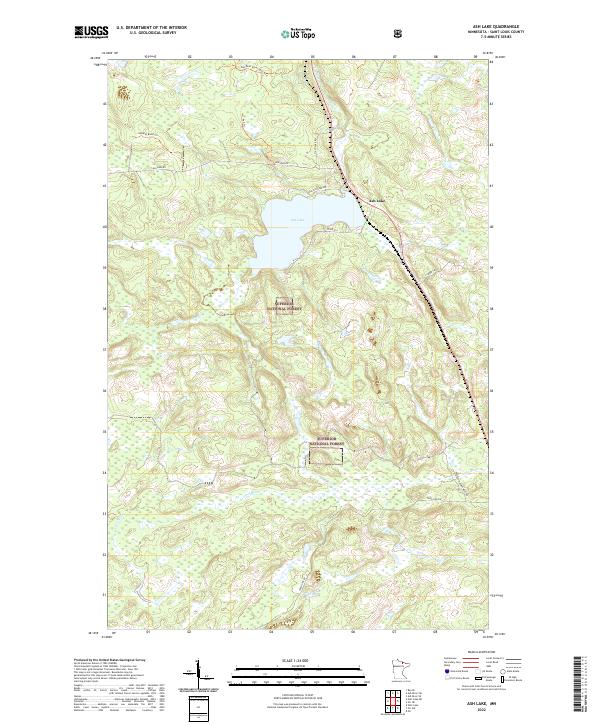
2022 Map of Ash Lake
USGS Topo · Published 2022About this map
The waters of Ash Lake and the Ash River define this portion of Saint Louis County within the Superior National Forest. This 2022 survey illustrates a landscape primarily shaped by conservation and resource management, dominated by a dense network of forest trails and access roads. Features such as the Lost River Management Rd, Rat Root River Spur B Trl, and Isabella Road Trl crisscross the wetland-rich terrain, suggesting the area's ongoing use for logging, recreation, and wilderness protection. To the south, the Lost River meanders through township lines, while the small settlement at Ash Lake serves as a localized point of human activity amidst the extensive public lands. The map provides a clear view of modern forest infrastructure, including several named routes like Lambert Rd and Co Rd 519 that connect this remote woodland to the wider region.
Find a feature on this map
22 named features on this map. Tap any name to fly to it.
Don’t see what you’re looking for? This feature index may not catch every label — zoom into the map to look around manually.
Map Details
Editions of this 2022 Ash Lake Map
This is the sole edition of this map. No revisions or reprints were ever made.
Other maps of this area

1954 · International Falls
USGS Topo · 1:250,000

1957 · International Falls
USGS Topo · 1:250,000

1958 · International Falls
USGS Topo · 1:250,000

1968 · Ash River SE
USGS Topo · 1:24,000

1968 · Ash Lake
USGS Topo · 1:24,000

1968 · Ash River SW
USGS Topo · 1:24,000
1968 · Orr NE
USGS Topo · 1:24,000

1968 · Orr SW
USGS Topo · 1:24,000
1968 · Orr
USGS Topo · 1:24,000

1969 · Ray SE
USGS Topo · 1:24,000