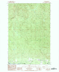
1987 Map of Ashford
USGS Topo · Published 1987About this map
Ashford sits in the river valley at the southern edge of this landscape, positioned along the border between Pierce and Lewis counties. The community is defined by its proximity to the Nisqually River, which flows westward across the bottom of the quadrangle. An Old Railroad Grade traces a path through the valley, indicating the area's history of timber transport or industrial transit. North of the river, the terrain is dominated by a complex network of drainage systems, including the Mashel River and the descriptively named Busy Wild Creek. The map reveals a post-war landscape of resource extraction and infrastructure, evidenced by numerous Borrow Pits and a small Landing Strip near the settlement. The presence of a Gaging Station on the Nisqually suggests the ongoing importance of river monitoring for this watershed during the late twentieth century.
Find a feature on this map
15 named features on this map. Tap any name to fly to it.
Don’t see what you’re looking for? This feature index may not catch every label — zoom into the map to look around manually.
Map Details
Editions of this 1987 Ashford Map
2 editions found
Other maps of this area

1924 · Mt Rainier
USGS Topo · 1:96,000

1928 · Mt Rainier
USGS Topo · 1:125,000

1937 · Eatonville
USGS Topo · 1:125,000

1950 · Yakima
USGS Topo · 1:250,000

1953 · Hoquiam
USGS Topo · 1:250,000

1956 · Mineral
USGS Topo · 1:62,500

1956 · Kapowsin
USGS Topo · 1:62,500

1957 · Hoquiam
USGS Topo · 1:250,000

1958 · Yakima
USGS Topo · 1:250,000

1958 · Hoquiam
USGS Topo · 1:250,000