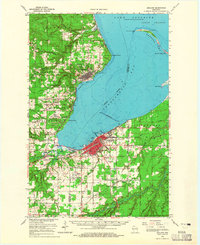
1964 Map of Ashland
USGS Topo · Published 1965About this map
Washburn and Ashland anchor this mid-1960s study of the Chequamegon Bay shoreline, where heavy industrial infrastructure meets the deep waters of Lake Superior. The landscape is defined by its maritime and rail heritage, featuring an extensive breakwater and a dense network of lines from the Chicago and North Western, Northern Pacific, and SoO Line. These railroads converge at Ashland Junction, illustrating the area's role as a shipping hub for the region's timber and minerals.
Find a feature on this map
75 named features on this map. Tap any name to fly to it.
Don’t see what you’re looking for? This feature index may not catch every label — zoom into the map to look around manually.
Map Details
Editions of this 1964 Ashland Map
2 editions found
Other maps of this area

1941 · Bayfield
USGS Topo · 1:48,000

1942 · Ashland
USGS Topo · 1:48,000

1942 · Mellen
USGS Topo · 1:48,000

1942 · Marengo
USGS Topo · 1:48,000

1943 · Odanah
USGS Topo · 1:48,000

1944 · Moquah
USGS Topo · 1:48,000

1944 · Cornucopia
USGS Topo · 1:48,000

1944 · Grandview
USGS Topo · 1:48,000

1945 · Odanah
USGS Topo · 1:48,000

1945 · Marengo
USGS Topo · 1:48,000