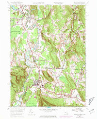
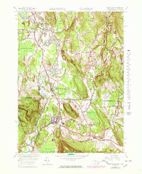
1958 Map of Ashley Falls
USGS Topo · Published 1978About this map
The Housatonic River snakes through the valley floor, creating a landscape of complex meanders and wetlands such as the Barnum Street Swamp and Robbins Swamp. This mid-century survey captures the tri-state border region as it was being modernized, with the Penn Central railroad corridors and state highways connecting established settlements like Sheffield, Canaan, and Ashley Falls. The map reveals a transition between the industrial and agricultural past and newer developments, including the Drive-in Theater near the river and educational institutions like the Berkshire School. Steep topographical features such as Miles Mtn and Rattlesnake Hill flank the valleys of the Konkapot River and Blackberry River, while local landmarks like the Mountain View Cem and Center Ch provide essential points of reference for genealogists tracking families in both Berkshire Co and Litchfield Co.
Find a feature on this map
68 named features on this map. Tap any name to fly to it.
Don’t see what you’re looking for? This feature index may not catch every label — zoom into the map to look around manually.
Map Details
Editions of this 1958 Ashley Falls Map
7 editions found
Other maps of this area

1885 · Sheffield
USGS Topo · 1:62,500

1888 · Sheffield
USGS Topo · 1:62,500

1888 · Sandisfield
USGS Topo · 1:62,500

1891 · Sheffield
USGS Topo · 1:62,500

1892 · Winsted
USGS Topo · 1:62,500

1892 · Cornwall
USGS Topo · 1:62,500

1893 · Sheffield
USGS Topo · 1:62,500

1893 · Cornwall
USGS Topo · 1:62,500

1893 · Sandisfield
USGS Topo · 1:62,500

1897 · Sandisfield
USGS Topo · 1:62,500