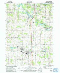
1993 Map of Ashley
USGS Topo · Published 1993About this map
The border of Steuben and DeKalb counties serves as the primary axis for this early 1990s study, where the communities of Ashley and Hudson sit side-by-side along the Norfolk and Western railroad corridor. This landscape is defined by its post-glacial hydrology, featuring a dense network of water bodies including Pigeon Creek, Mink Lake, and the expansive Pleasant Lake. The map details a transition from the agricultural fields of Jackson and Salem townships to the recreational and residential pockets surrounding the lakes. Genealogists and local historians can pinpoint several rural landmarks, such as Mt Zion Ch and Hollister Cem, alongside modern infrastructure like Interchange 140 on the interstate and the local Fish Hatchery near the community of Pleasant Lake.
Find a feature on this map
54 named features on this map. Tap any name to fly to it.
Don’t see what you’re looking for? This feature index may not catch every label — zoom into the map to look around manually.
Map Details
Editions of this 1993 Ashley Map
This is the sole edition of this map. No revisions or reprints were ever made.
Other maps of this area

1939 · Hamilton
USGS Topo · 1:24,000

1939 · Angola East
USGS Topo · 1:24,000

1940 · Orland
USGS Topo · 1:24,000

1941 · Orland
USGS Topo · 1:24,000

1941 · Angola West
USGS Topo · 1:24,000

1942 · Ashley
USGS Topo · 1:24,000

1942 · Angola West
USGS Topo · 1:24,000

1942 · Stroh
USGS Topo · 1:24,000

1947 · Angola East
USGS Topo · 1:24,000

1948 · Hamilton
USGS Topo · 1:24,000