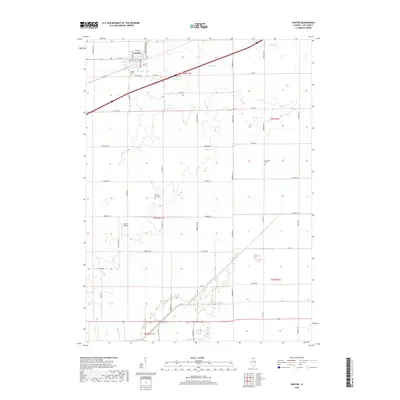
2018 Map of Ashton
USGS Topo · Published 2018About this map
The village of Ashton serves as the primary hub in this corner of Lee County, its residential grid organized around Main St and Cartwright Ave. The landscape is defined by a dense network of country roads following the township and range survey lines, reflecting the deep agricultural roots of north-central Illinois. Genealogists can locate family burial sites at several small grounds throughout the area, including the Ashton Cem on the outskirts of town, the Reynolds Cem to the east, and the Gehant Farm Cem situated further south. The terrain is marked by gentle drainage basins including Beach Cr and Willow Cr, which eventually feed into the Green River. Notable aviation history is represented by the presence of Miller Airport, while the surrounding land remains largely dedicated to farming, connected by thoroughfares such as Reynolds Rd and McGirr Rd.
Find a feature on this map
47 named features on this map. Tap any name to fly to it.
Don’t see what you’re looking for? This feature index may not catch every label — zoom into the map to look around manually.
Map Details
Editions of this 2018 Ashton Map
This is the sole edition of this map. No revisions or reprints were ever made.
Other maps of this area

1918 · Dixon
USGS Topo · 1:62,500

1950 · Dixon
USGS Topo · 1:62,500

1951 · Amboy
USGS Topo · 1:62,500

1952 · Rochelle
USGS Topo · 1:62,500

1952 · Mendota
USGS Topo · 1:62,500

1958 · Aurora
USGS Topo · 1:250,000

1961 · Aurora
USGS Topo · 1:250,000
1975 · Rochelle
USGS Topo · 1:24,000
1975 · Steward
USGS Topo · 1:24,000
1975 · Chana
USGS Topo · 1:24,000