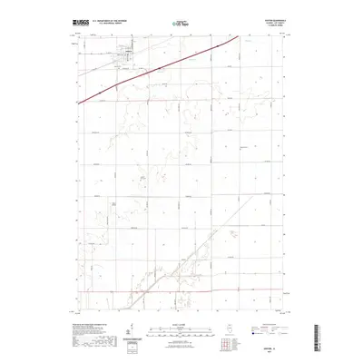
2021 Map of Ashton
USGS Topo · Published 2021About this map
Ashton anchors the northern reaches of this Lee County landscape, situated where local thoroughfares like Main St and Cartwright Ave intersect. The surrounding agricultural terrain is etched by the drainage of Beach Cr and the Green River, showing a grid of rural roads named for long-standing local families. Genealogists and historians can locate several burial sites throughout the township, including the Ashton Cem near the town center, the Gehant Farm Cem further south, and the isolated Reynolds Cem to the east. Transportation patterns are defined by the straight runs of Meridian Rd and Car Line Rd, while the private Miller Airport stands as a distinct aeronautical landmark amidst the fields. This map preserves the rural character and land ownership boundaries of the region as they appeared in the early 21st century.
Find a feature on this map
44 named features on this map. Tap any name to fly to it.
Don’t see what you’re looking for? This feature index may not catch every label — zoom into the map to look around manually.
Map Details
Editions of this 2021 Ashton Map
This is the sole edition of this map. No revisions or reprints were ever made.
Other maps of this area

1918 · Dixon
USGS Topo · 1:62,500

1950 · Dixon
USGS Topo · 1:62,500

1951 · Amboy
USGS Topo · 1:62,500

1952 · Rochelle
USGS Topo · 1:62,500

1952 · Mendota
USGS Topo · 1:62,500

1958 · Aurora
USGS Topo · 1:250,000

1961 · Aurora
USGS Topo · 1:250,000
1975 · Rochelle
USGS Topo · 1:24,000
1975 · Steward
USGS Topo · 1:24,000
1975 · Chana
USGS Topo · 1:24,000