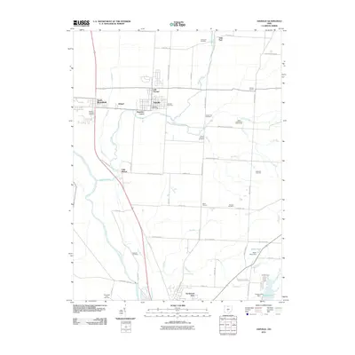
2010 Map of Ashville
USGS Topo · Published 2010About this map
The Scioto River defines the western edge of this central Ohio landscape, where the town of Ashville and neighboring South Bloomfield serve as the primary population centers. The area is characterized by a dense network of watercourses, including Walnut Creek, Little Walnut Creek, and several branches of Dry Run, which move through the fertile bottomlands. These natural features dictated early settlement patterns and the placement of numerous family and township burial grounds. Genealogists will find a high density of rural cemeteries, such as the A R Duvall Cemetery, Reber Hill Cemetery, and the Shortridge Farm Cemetery. Small, localized place names like Little Chicago and Millport reflect the gradual growth and infill between established towns. At the southern edge, Northwood Park and the recreation areas surrounding Hargus Lake provide a modern contrast to the surrounding agricultural grid and older crossroads like Ward Corners and Brinker Corners.
Find a feature on this map
57 named features on this map. Tap any name to fly to it.
Don’t see what you’re looking for? This feature index may not catch every label — zoom into the map to look around manually.
Map Details
Editions of this 2010 Ashville Map
This is the sole edition of this map. No revisions or reprints were ever made.
Other maps of this area

1911 · Era
USGS Topo · 1:62,500

1913 · Era
USGS Topo · 1:62,500

1914 · Circleville
USGS Topo · 1:62,500

1923 · West Columbus
USGS Topo · 1:62,500

1925 · East Columbus
USGS Topo · 1:62,500

1925 · West Columbus
USGS Topo · 1:62,500

1943 · Era
USGS Topo · 1:62,500

1943 · Circleville
USGS Topo · 1:62,500

1943 · East Columbus
USGS Topo · 1:62,500

1947 · Columbus
USGS Topo · 1:250,000