1975 Map of Ashville
USGS Topo · Published 1977About this map
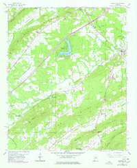
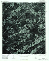
Ashville serves as the focal point of this 1975 orthophotograph, situated where the rolling hills of St. Clair County meet the winding course of Big Canoe Creek. Unlike traditional topographic maps, this aerial perspective, captured in early December, reveals the exact textures of the mid-1970s landscape, from the clearing of farm plots and woodlots to the distinct path of the interstate cutting diagonally through the terrain. To the north, the settlement of Whitney is visible near the corridor of the Southern Railway. The imagery provides a clear record of the region's land use patterns, contrasting the dense forest cover on the ridges with the managed agricultural fields and growing residential footprints around the historic county seat.
Find a feature on this map
3 named features on this map. Tap any name to fly to it.
Don’t see what you’re looking for? This feature index may not catch every label — zoom into the map to look around manually.
Map Details
Editions of this 1975 Ashville Map
This is the sole edition of this map. No revisions or reprints were ever made.
Historical Maps of Ashville Through Time
7 maps found