
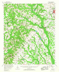
1957 Map of Ashwood
USGS Topo · Published 1958About this map
The Black River headwaters and a network of agricultural swamps dominate this mid-century landscape in Lee and Sumter counties. At the heart of the region, Ashwood appears as a planned rural community centered on Ashwood Lake and the Ashwood Raceway, reflecting New Deal-era resettlement efforts that transformed the local economy. The terrain is a complex drainage basin defined by Scrape Swamp, Rocky Bluff Swamp, and Raitting Creek, where several old mill sites like McGirts Millpond and Corbitts Millpond mark the historical reliance on water power.
Find a feature on this map
108 named features on this map. Tap any name to fly to it.
Don’t see what you’re looking for? This feature index may not catch every label — zoom into the map to look around manually.
Map Details
Editions of this 1957 Ashwood Map
2 editions found
Other maps of this area

1920 · Mayesville
USGS Topo · 1:48,000

1921 · Mayesville
USGS Topo · 1:62,500

1935 · Camden
USGS Topo · 1:48,000

1938 · Camden
USGS Topo · 1:62,500

1938 · Hagood
USGS Topo · 1:62,500

1941 · Spartanburg
USGS Topo · 1:250,000

1942 · Camden
USGS Topo · 1:125,000

1943 · Mayesville
USGS Topo · 1:62,500

1943 · Eastover
USGS Topo · 1:62,500

1946 · Sumter
USGS Topo · 1:62,500