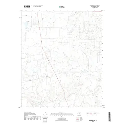
2019 Map of Aspermont Lake
USGS Topo · Published 2019About this map
Aspermont serves as the focal point for this section of Stonewall County, situated where a network of rural roads such as C R 100 and C R 402 converge. The landscape is defined by the winding course of the Double Mountain Fork Brazos River which cuts through the southern portion of the quadrangle. This riparian corridor is joined by several tributaries including Hitson Cr and Moore Cr, reflecting the drainage patterns of this semi-arid Texas region.
Find a feature on this map
23 named features on this map. Tap any name to fly to it.
Don’t see what you’re looking for? This feature index may not catch every label — zoom into the map to look around manually.
Map Details
Editions of this 2019 Aspermont Lake Map
This is the sole edition of this map. No revisions or reprints were ever made.
Other maps of this area

1893 · Roby
USGS Topo · 1:125,000

1925 · Aspermont 4-a
USGS Topo · 1:48,000

1931 · Rotan
USGS Topo · 1:62,500

1931 · Aspermont
USGS Topo · 1:62,500

1954 · Lubbock
USGS Topo · 1:250,000

1954 · Big Spring
USGS Topo · 1:250,000

1958 · Big Spring
USGS Topo · 1:250,000
1962 · Frog Mountain
USGS Topo · 1:24,000
1965 · Hamlin NE
USGS Topo · 1:24,000
1965 · Hamlin NW
USGS Topo · 1:24,000