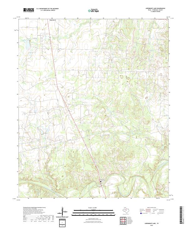
2022 Map of Aspermont Lake
USGS Topo · Published 2022About this map
Aspermont occupies the northern edge of this landscape, where the ranching country of Stonewall County meets the dramatic drainage of the Double Mountain Fork Brazos River. The terrain is defined by a network of seasonal watercourses and stock tanks, including West Tank and East Tank, which supported the region's agricultural history. Further south near the riverbanks, Rath City and the Boot Hill Cem mark a site of significant frontier heritage. The winding paths of Tonk Creek, Hitson Cr, and Willow Cr carve through the breaks, illustrating the complex erosion patterns that characterize this portion of the Texas Rolling Plains. The layout of county roads, such as Co RD 476 and C R 470, follows the natural contours and property lines established during the settlement of the area, providing a clear view of land use and connectivity in this rural corridor.
Find a feature on this map
25 named features on this map. Tap any name to fly to it.
Don’t see what you’re looking for? This feature index may not catch every label — zoom into the map to look around manually.
Map Details
Editions of this 2022 Aspermont Lake Map
This is the sole edition of this map. No revisions or reprints were ever made.
Other maps of this area

1893 · Roby
USGS Topo · 1:125,000

1925 · Aspermont 4-a
USGS Topo · 1:48,000

1931 · Rotan
USGS Topo · 1:62,500

1931 · Aspermont
USGS Topo · 1:62,500

1954 · Lubbock
USGS Topo · 1:250,000

1954 · Big Spring
USGS Topo · 1:250,000

1958 · Big Spring
USGS Topo · 1:250,000
1962 · Frog Mountain
USGS Topo · 1:24,000
1965 · Hamlin NE
USGS Topo · 1:24,000
1965 · Hamlin NW
USGS Topo · 1:24,000