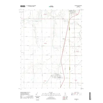
2018 Map of Assumption
USGS Topo · Published 2018About this map
Assumption and Moweaqua anchor this central Illinois landscape, showing the organized grid of Christian and Shelby counties in 2018. The map details a predominantly agricultural region defined by a sophisticated network of local roads such as Co RD 1800 N and Co RD 1300 N, which facilitate movement between rural homesteads and the larger settlements. Local history is anchored at Saint Marys Cem and Hayes Cem, while the natural drainage of the prairie is visible through the winding paths of Flat Branch and Big George Br. The presence of Radford and the detailed street layout of the primary towns, including S Railroad Ave in Moweaqua, illustrate how these communities grew along the corridors of the regional rail and road infrastructure. This study traces the subtle topographic variations and watercourses like Oak Br and Sorghum Br that continue to shape the development of the Illinois farm belt.
Find a feature on this map
75 named features on this map. Tap any name to fly to it.
Don’t see what you’re looking for? This feature index may not catch every label — zoom into the map to look around manually.
Map Details
Editions of this 2018 Assumption Map
This is the sole edition of this map. No revisions or reprints were ever made.
Other maps of this area

1942 · Shelbyville
USGS Topo · 1:62,500

1946 · Shelbyville
USGS Topo · 1:62,500

1947 · Pana
USGS Topo · 1:62,500

1949 · Dalton City
USGS Topo · 1:62,500

1949 · Pana
USGS Topo · 1:62,500

1952 · Assumption
USGS Topo · 1:62,500

1958 · Decatur
USGS Topo · 1:250,000

1961 · Decatur
USGS Topo · 1:250,000

1974 · Willeys
USGS Topo · 1:24,000
1981 · Tower Hill
USGS Topo · 1:24,000