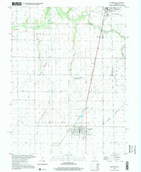
1998 Map of Assumption
USGS Topo · Published 2002About this map
Assumption serves as the primary hub in this Illinois landscape, situated at the intersection of the Consolidated Rail Corporation line and local rural routes. The map illustrates a meticulously organized agricultural grid across Prairieton and Assumption townships, where the terrain is dissected by numerous waterways including Willow Branch, Oak Branch, and the Sorghum Branch. Cultural landmarks such as Motion Raceway and a Tank Farm indicate the area's mid-century industrial and recreational development alongside its farming roots.
Find a feature on this map
25 named features on this map. Tap any name to fly to it.
Don’t see what you’re looking for? This feature index may not catch every label — zoom into the map to look around manually.
Map Details
Editions of this 1998 Assumption Map
This is the sole edition of this map. No revisions or reprints were ever made.
Other maps of this area

1942 · Shelbyville
USGS Topo · 1:62,500

1946 · Shelbyville
USGS Topo · 1:62,500

1947 · Pana
USGS Topo · 1:62,500

1949 · Dalton City
USGS Topo · 1:62,500

1949 · Pana
USGS Topo · 1:62,500

1952 · Assumption
USGS Topo · 1:62,500

1958 · Decatur
USGS Topo · 1:250,000

1961 · Decatur
USGS Topo · 1:250,000

1974 · Willeys
USGS Topo · 1:24,000
1981 · Tower Hill
USGS Topo · 1:24,000