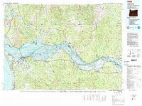
1981 Map of Astoria
USGS Topo · Published 1989About this map
The Columbia River dominates this coastal landscape as it flows past the historic port of Astoria toward the Pacific Ocean. This survey details the complex estuarine environment at the river's mouth, where the Lewis and Clark National Wildlife Refuge encompasses a vast network of islands and marshes including Karlson Island and Marsh Island. To the west, Fort Stevens State Park and Hammond guard the south bank, while the northern shore features small riverfront settlements like Chinook and McGowan.
Find a feature on this map
149 named features on this map. Tap any name to fly to it.
Don’t see what you’re looking for? This feature index may not catch every label — zoom into the map to look around manually.
Map Details
Editions of this 1981 Astoria Map
3 editions found
Other maps of this area

1916 · Chehalis
USGS Topo · 1:125,000

1919 · Mayger
USGS Topo · 1:62,500

1919 · Astoria
USGS Topo · 1:62,500

1921 · Kalama
USGS Topo · 1:62,500

1922 · St. Helens
USGS Topo · 1:62,500

1938 · Cape Disappointment
USGS Topo · 1:62,500

1938 · Cape Shoalwater
USGS Topo · 1:62,500

1938 · Fort Columbia
USGS Topo · 1:62,500

1938 · South Bend
USGS Topo · 1:62,500

1939 · Astoria
USGS Topo · 1:62,500