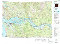
1981 Map of Astoria
USGS Topo · Published 1989About this map
The Columbia River dominates this 1981 survey, serving as a massive conduit between the Pacific Ocean and the industrial hubs of Longview and Astoria. This edition includes detailed bathymetry, revealing the complex underwater topography of the estuary including Desdemona Sands and various shipping channels. Along the river's winding path, a network of islands like Puget Island, Marsh Island, and Crims Island illustrates the shifting nature of the delta. On the Oregon side, the Clatsop State Forest covers much of the interior, while the Washington shore is defined by the Lewis and Clark National Wildlife Refuge. Regional transportation is anchored by the Burlington Northern Railroad and US Highway 101, connecting coastal settlements like Seaside, Warrenton, and Gearhart. Local history is preserved in the location of Greenwood Cem and Ocean View Cem, while smaller landings such as Skamokawa and Knappa point to the area's river-dependent economy.
Find a feature on this map
192 named features on this map. Tap any name to fly to it.
Don’t see what you’re looking for? This feature index may not catch every label — zoom into the map to look around manually.
Map Details
Editions of this 1981 Astoria Map
3 editions found
Other maps of this area

1916 · Chehalis
USGS Topo · 1:125,000

1919 · Mayger
USGS Topo · 1:62,500

1919 · Astoria
USGS Topo · 1:62,500

1921 · Kalama
USGS Topo · 1:62,500

1922 · St. Helens
USGS Topo · 1:62,500

1938 · Cape Disappointment
USGS Topo · 1:62,500

1938 · Cape Shoalwater
USGS Topo · 1:62,500

1938 · Fort Columbia
USGS Topo · 1:62,500

1938 · South Bend
USGS Topo · 1:62,500

1939 · Astoria
USGS Topo · 1:62,500