
Loading...
Loading map...1980 Map of Athens
USGS Topo · Published 1981About this map
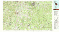
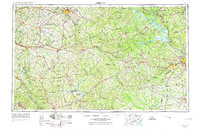
The Athens area of North Georgia shows a complex landscape of Piedmont plateau agriculture and expanding municipal centers as they appeared in 1980. The map centers on the college city, where the Middle Oconee River and North Oconee River converge. Radiating outward, the regional infrastructure is defined by the Seaboard Coast Line and Georgia Railroad, which connect established hubs like Monroe, Winder, and Covington.
Find a feature on this map
128 named features on this map. Tap any name to fly to it.
Don’t see what you’re looking for? This feature index may not catch every label — zoom into the map to look around manually.
Map Details
Date Portrayed1980
Date Published1981
PublisherU.S. Geological Survey
Map TypeTopographic
Scale1:100,000
Physical Dimensions44 x 24 inches
Editions of this 1980 Athens Map
2 editions found
Historical Maps of Athens Through Time
6 maps found


Featured Locations
Source Details
SourceU.S. Geological Survey
CopyrightPublic Domain