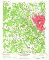
1964 Map of Athens West
USGS Topo · Published 1967About this map
The Middle Oconee River and Oconee River converge south of a rapidly expanding Athens, Georgria, in the mid-1960s. This survey illustrates a period of significant institutional growth, anchored by the University of Georgia and the US Naval Supply Corps School. The urban core is surrounded by essential local landmarks of the era, from the Athens Speedway and a Drive-in Theater to the Beechwood Shopping Center.
Find a feature on this map
88 named features on this map. Tap any name to fly to it.
Don’t see what you’re looking for? This feature index may not catch every label — zoom into the map to look around manually.
Map Details
Editions of this 1964 Athens West Map
5 editions found
Other maps of this area

1891 · Gainesville
USGS Topo · 1:125,000

1891 · Carnesville
USGS Topo · 1:125,000

1896 · Monroe
USGS Topo · 1:125,000

1953 · Athens
USGS Topo · 1:250,000

1954 · Greenville
USGS Topo · 1:250,000

1958 · Greenville
USGS Topo · 1:250,000

1958 · Athens
USGS Topo · 1:250,000

1959 · Athens
USGS Topo · 1:250,000

1963 · Athens
USGS Topo · 1:250,000

1964 · Athens West
USGS Topo · 1:24,000