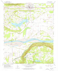
1961 Map of Atkins
USGS Topo · Published 1976About this map
Atkins sits at the northern edge of this Arkansas River valley landscape, serving as a hub for the Missouri Pacific railroad and U.S. Highway 64. The town's grid extends toward the prominent Gum Log Mountain and Carrion Crow Mountain to the north, while the southern terrain is dominated by the wide flats of Carden Bottom and the massive Petit Jean Mountain. This rugged highland is home to Petit Jean State Park, featuring a dense cluster of small recreation lakes such as Lake Abby and Lake Bailey, alongside landmarks like Cedar Falls. Between the mountains and the river, the landscape is dotted with rural institutions like Bells Chapel, Gold Hill Sch, and Darr Cem, illustrating the mid-century community structure of Pope County and Yell County. Significant infrastructure including the Spillway 319 at Lake Atkins and several rural landing strips highlight the era's water management and local aviation.
Find a feature on this map
52 named features on this map. Tap any name to fly to it.
Don’t see what you’re looking for? This feature index may not catch every label — zoom into the map to look around manually.
Map Details
Editions of this 1961 Atkins Map

Other maps of this area

1888 · Dardanelle #4
USGS Topo · 1:62,500

1888 · Dardanelle #1
USGS Topo · 1:62,500

1889 · Morrilton No. 3
USGS Topo · 1:62,500

1890 · Dardanelle
USGS Topo · 1:125,000

1892 · Morrillton
USGS Topo · 1:125,000

1894 · Morrillton
USGS Topo · 1:125,000

1956 · Russellville
USGS Topo · 1:250,000

1961 · Perryville
USGS Topo · 1:24,000

1961 · Morrilton West
USGS Topo · 1:24,000

1961 · Adona
USGS Topo · 1:24,000