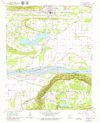
1961 Map of Atkins
USGS Topo · Published 1979About this map
Petit Jean State Park anchors the southern portion of this landscape, where the Petit Jean Mountain rises sharply above the Arkansas River valley. To the north, the town of Atkins serves as a central hub along the Missouri Pacific railroad, which runs parallel to the base of Gum Log Mountain. The topography shifts from the flat river plains of Carden Bottom and Sweeden Island to the higher elevations and intricate shoreline of Lake Atkins. Local heritage is preserved in the numerous community landmarks such as Bells Chapel, Gold Hill Sch, and the historic Galla Rock settlement near the riverbanks. The survey captures the complex water network of the Petit Jean River and its various lakes, including Lake Lucy and Lake Bailey, reflecting an area defined by both its natural recreation and agricultural productivity.
Find a feature on this map
54 named features on this map. Tap any name to fly to it.
Don’t see what you’re looking for? This feature index may not catch every label — zoom into the map to look around manually.
Map Details
Editions of this 1961 Atkins Map

Other maps of this area

1888 · Dardanelle #4
USGS Topo · 1:62,500

1888 · Dardanelle #1
USGS Topo · 1:62,500

1889 · Morrilton No. 3
USGS Topo · 1:62,500

1890 · Dardanelle
USGS Topo · 1:125,000

1892 · Morrillton
USGS Topo · 1:125,000

1894 · Morrillton
USGS Topo · 1:125,000

1956 · Russellville
USGS Topo · 1:250,000

1961 · Perryville
USGS Topo · 1:24,000

1961 · Morrilton West
USGS Topo · 1:24,000

1961 · Adona
USGS Topo · 1:24,000