Loading...
Loading map...1907 Map of Atlanta
USGS Topo · Published 1958About this map
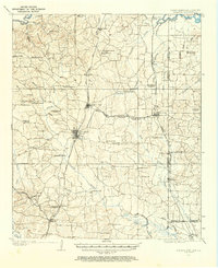
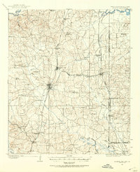
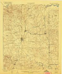
The Texas and Pacific and Kansas City Southern railroads define the industrial character of this tri-state border region during the early twentieth century. Centered on Atlanta and Queen City, the map documents a landscape where timber and agriculture were the primary economic drivers. Numerous family-run operations, such as Arnolds Sawmill, Richards Sawmill, and Chambee's Gin, are scattered along the drainages of Black Creek and Hurricane Bayou.
Find a feature on this map
75 named features on this map. Tap any name to fly to it.
Don’t see what you’re looking for? This feature index may not catch every label — zoom into the map to look around manually.
Map Details
Date Portrayed1907
Date Published1958
PublisherU.S. Geological Survey
Map TypeTopographic
Scale1:62,500
Physical Dimensions17 x 20.9 inches
Editions of this 1907 Atlanta Map
2 editions found
Historical Maps of Atlanta Through Time
Featured Locations
Source Details
SourceU.S. Geological Survey
CopyrightPublic Domain