
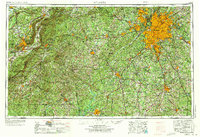
1953 Map of Atlanta
USGS Topo · Published 1965About this map
Atlanta dominates the northeast quadrant of this mid-century regional study, showing the city's expansion through East Point, Hapeville, and Decatur before the full development of the interstate system. The industrial and military corridor stretching west into Alabama is anchored by Anniston and the extensive Fort McClellan Military Reservation, alongside the Anniston Ordnance Depot. The landscape transitions from the metropolitan sprawl near Stone Mountain to the protected woodlands of the Talladega National Forest.
Find a feature on this map
89 named features on this map. Tap any name to fly to it.
Don’t see what you’re looking for? This feature index may not catch every label — zoom into the map to look around manually.
Map Details
Editions of this 1953 Atlanta Map
2 editions found
Other maps of this area

1885 · Gadsden
USGS Topo · 1:125,000

1886 · Rome
USGS Topo · 1:125,000

1888 · Gadsden
USGS Topo · 1:125,000

1888 · Atlanta
USGS Topo · 1:125,000

1889 · Tallapoosa
USGS Topo · 1:125,000

1889 · Springville
USGS Topo · 1:125,000

1890 · Suwanee
USGS Topo · 1:125,000

1890 · Cartersville
USGS Topo · 1:125,000

1890 · Talladega
USGS Topo · 1:125,000

1890 · Atlanta
USGS Topo · 1:125,000