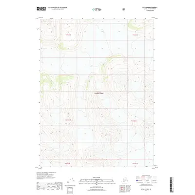
2017 Map of Atlin A-8 NW
USGS Topo · Published 2017About this map
Tongass National Forest dominates this Alaskan landscape, revealed through dense contour lines that trace the steep verticality of the Haines Borough interior. Unlike more developed regions, this 2017 survey shows a terrain defined by its natural topography rather than human infrastructure or settlements. The map highlights the complex Public Land Survey System divisions, including t30s r62e, t31s r62e, and t32s r63e, which provide the essential framework for land management within the forest boundaries. The absence of roads or named settlements underscores the wild character of this territory, where the physical geography of the Alaska-Haines region remains the primary feature for study and navigation.
Find a feature on this map
7 named features on this map. Tap any name to fly to it.
Don’t see what you’re looking for? This feature index may not catch every label — zoom into the map to look around manually.
Map Details
Editions of this 2017 Atlin A-8 NW Map
This is the sole edition of this map. No revisions or reprints were ever made.
Other maps of this area

1948 · Skagway A-1
USGS Topo · 1:63,360

1949 · Atlin
USGS Topo · 1:250,000

1949 · Skagway B-1
USGS Topo · 1:63,360

1951 · Skagway A-1
USGS Topo · 1:63,360

1951 · Atlin
USGS Topo · 1:250,000

1951 · Skagway B-1
USGS Topo · 1:63,360

1952 · Skagway
USGS Topo · 1:250,000

1960 · Atlin A-8
USGS Topo · 1:63,360
1960 · Atlin B-8
USGS Topo · 1:63,360

1960 · Atlin
USGS Topo · 1:250,000