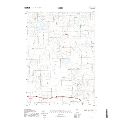
2019 Map of Attica
USGS Topo · Published 2019About this map
Attica and Lum anchor this Lapeer County landscape, where complex drainage systems and glacially-formed lakes define the local geography. The area is characterized by an extensive network of managed waterways, including the Palmer Br Drain, Sickles Drain, and Earl Br Drain, which navigate the terrain between significant water bodies like Lake Pleasant and Fish Lake. The Polly Ann State Trail cuts a diagonal path through the northern half of the quadrangle, following a former rail corridor that historically connected these rural communities. For those researching local families, the map identifies several burial grounds, including Bahel Cem, Lum Cem, Attica Cem, and Roscoe Cem, reflecting the distribution of early settlements. The southern portion of the sheet is marked by the headwaters of the Belle River and the N Br Belle River, showing the transition from marshy lowlands to a more defined river system.
Find a feature on this map
113 named features on this map. Tap any name to fly to it.
Don’t see what you’re looking for? This feature index may not catch every label — zoom into the map to look around manually.
Map Details
Editions of this 2019 Attica Map
This is the sole edition of this map. No revisions or reprints were ever made.
Other maps of this area

1943 · Metamora
USGS Topo · 1:24,000

1945 · Almont
USGS Topo · 1:24,000

1945 · Thornville
USGS Topo · 1:24,000

1946 · Metamora
USGS Topo · 1:24,000

1954 · Detroit
USGS Topo · 1:250,000

1954 · Flint
USGS Topo · 1:250,000

1958 · Flint
USGS Topo · 1:250,000

1961 · Detroit
USGS Topo · 1:250,000

1963 · Attica
USGS Topo · 1:24,000

1963 · North Branch
USGS Topo · 1:24,000