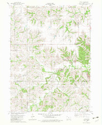
1982 Map of Attica
USGS Topo · Published 1983About this map
Attica serves as the primary settlement in this part of Marion County, situated on the high ground between Walnut Creek and the headwaters of the southern drainage systems. The landscape is defined by the transition from upland agricultural plateaus to the intricate creek valleys of North Cedar Creek and Columbia Creek. Evidence of the region's industrial activity is prominently marked by several Strip Mines located east of Indiana Chapel, showing where the surface has been worked for coal extraction near the county lines.
Find a feature on this map
30 named features on this map. Tap any name to fly to it.
Don’t see what you’re looking for? This feature index may not catch every label — zoom into the map to look around manually.
Map Details
Editions of this 1982 Attica Map
This is the sole edition of this map. No revisions or reprints were ever made.
Other maps of this area

1909 · Knoxville
USGS Topo · 1:62,500

1910 · Pella
USGS Topo · 1:62,500

1912 · Knoxville
USGS Topo · 1:62,500

1912 · Pella
USGS Topo · 1:62,500

1924 · Melcher
USGS Topo · 1:62,500

1929 · Albia
USGS Topo · 1:62,500

1954 · Des Moines
USGS Topo · 1:250,000

1956 · Des Moines
USGS Topo · 1:250,000

1957 · Des Moines
USGS Topo · 1:250,000
1965 · Knoxville SW
USGS Topo · 1:24,000
Featured Places
- Indiana Township, IA
- Knoxville Township, IA
- Washington Township, IA
- Attica, Indiana Township
- Marion County, IA