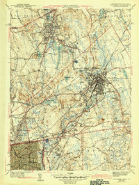
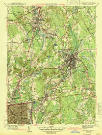
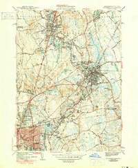
1943 Map of Attleboro
USGS Topo · Published 1943About this map
Industrial and institutional centers define this 1943 survey, where the New York New Haven and Hartford Railroad links the urban core of Attleboro to its surrounding textile and jewelry manufacturing hamlets. The landscape is dotted with early healthcare and community landmarks, most notably the Attleboro Springs Sanitarium and the County Sanitarium to the east. The Tenmile River and Bungay River power the mills at Dodgeville and Hebronville, while the northern portion of the quadrangle shows the established residential growth around North Attleboro and Plainville.
Find a feature on this map
98 named features on this map. Tap any name to fly to it.
Don’t see what you’re looking for? This feature index may not catch every label — zoom into the map to look around manually.
Map Details
Editions of this 1943 Attleboro Map
3 editions found
Other maps of this area

1885 · Taunton
USGS Topo · 1:62,500

1886 · Dedham
USGS Topo · 1:62,500

1887 · Franklin
USGS Topo · 1:62,500

1887 · Providence
USGS Topo · 1:62,500

1888 · Taunton
USGS Topo · 1:62,500

1889 · Providence
USGS Topo · 1:62,500

1889 · Franklin
USGS Topo · 1:62,500

1893 · Taunton
USGS Topo · 1:62,500

1893 · Franklin
USGS Topo · 1:62,500

1894 · Dedham
USGS Topo · 1:62,500