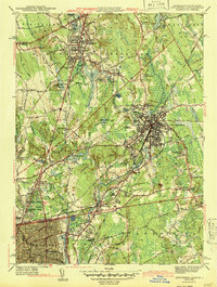
1943 Map of Attleboro
USGS Topo · Published 1943About this map
Attleboro and its industrial satellites are depicted here in the years leading into the mid-century, showing a landscape defined by the New York New Haven and Hartford railroad and the winding course of the Ten Mile River. The map reveals the intricate development of manufacturing villages like Attleboro Falls, Dodgeville, and Hebronville, where textile and jewelry heritage is implied by the dense grid of worker housing and proximity to the river.
Find a feature on this map
107 named features on this map. Tap any name to fly to it.
Don’t see what you’re looking for? This feature index may not catch every label — zoom into the map to look around manually.
Map Details
Editions of this 1943 Attleboro Map
3 editions found
Other maps of this area

1885 · Taunton
USGS Topo · 1:62,500

1886 · Dedham
USGS Topo · 1:62,500

1887 · Franklin
USGS Topo · 1:62,500

1887 · Providence
USGS Topo · 1:62,500

1888 · Taunton
USGS Topo · 1:62,500

1889 · Providence
USGS Topo · 1:62,500

1889 · Franklin
USGS Topo · 1:62,500

1893 · Taunton
USGS Topo · 1:62,500

1893 · Franklin
USGS Topo · 1:62,500

1894 · Dedham
USGS Topo · 1:62,500