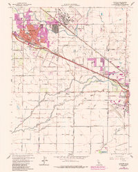
1960 Map of Atwater
USGS Topo · Published 1987About this map
Castle Air Force Base dominates the northern landscape of this Central Valley survey, showcasing its extensive runway and military facilities adjacent to Castle Gardens and the settlement of Fluhr. The city of Atwater serves as the primary hub, where the Southern Pacific and Atchison Topeka and Santa Fe railroads intersect near City Hall and several local campuses, including High Sch and St Anthony Sch. The surrounding agricultural plain is defined by a complex network of irrigation and drainage, with the Main Canal and Livingston Canal feeding into the territory. Cultural landmarks like the County Honor Farm and Merced Municipal Airport indicate the region's mid-century development. Waterways such as Bear Creek and Black Rascal Slough meander across the southern reaches, crossed by Dickenson Ferry Road, reflecting an era of transition as rural homesteads and schools like McSwain School began to integrate with expanding urban boundaries.
Find a feature on this map
58 named features on this map. Tap any name to fly to it.
Don’t see what you’re looking for? This feature index may not catch every label — zoom into the map to look around manually.
Map Details
Editions of this 1960 Atwater Map
4 editions found
Other maps of this area

1914 · Merced
USGS Topo · 1:31,680

1916 · Hopeton
USGS Topo · 1:31,680

1916 · Cressey
USGS Topo · 1:31,680

1917 · Winton
USGS Topo · 1:31,680

1917 · Merced
USGS Topo · 1:31,680

1918 · Arena
USGS Topo · 1:31,680

1918 · Lingard
USGS Topo · 1:31,680

1918 · Atwater
USGS Topo · 1:31,680

1918 · Sandy Mush
USGS Topo · 1:31,680

1918 · Turner Ranch
USGS Topo · 1:31,680