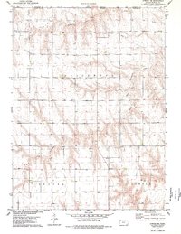
1978 Map of Atwood NE
USGS Topo · Published 1979About this map
Horinek and the nearby Townhall sit among the high plains of northern Kansas in this late-1970s topographical record. The landscape is defined by the drainage of the South Fork Driftwood Creek, which carves through the terrain alongside Wildhorse Canyon. Local community life is anchored by St Cyril Ch and an adjacent Cem, providing valuable points of reference for genealogists tracking families in this part of Rawlins County. The map also documents the industrial presence of an Oil Field and scattered Drill Holes, showing the intersection of agriculture and energy extraction along the Nebraska-Kansas border. The townships of Driftwood, Atwood, and Beaver divide the territory, which was field-checked just a few years before publication.
Find a feature on this map
13 named features on this map. Tap any name to fly to it.
Don’t see what you’re looking for? This feature index may not catch every label — zoom into the map to look around manually.
Map Details
Editions of this 1978 Atwood NE Map
This is the sole edition of this map. No revisions or reprints were ever made.
Other maps of this area

1951 · Herndon
USGS Topo · 1:62,500

1951 · Atwood
USGS Topo · 1:62,500

1954 · McCook
USGS Topo · 1:250,000

1954 · Goodland
USGS Topo · 1:250,000

1956 · Goodland
USGS Topo · 1:250,000

1957 · McCook
USGS Topo · 1:250,000

1957 · Goodland
USGS Topo · 1:250,000

1958 · McCook
USGS Topo · 1:250,000

1962 · Trenton SW
USGS Topo · 1:24,000

1962 · Culbertson SW
USGS Topo · 1:24,000