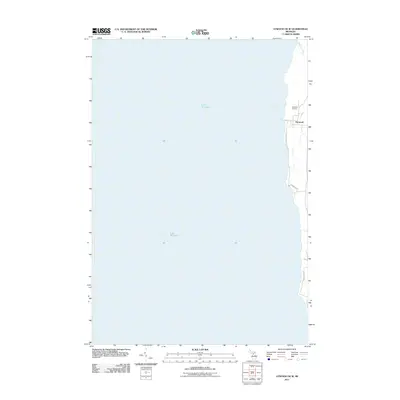
2011 Map of Atwood OE W
USGS Topo · Published 2011About this map
The settlement of Norwood sits at the water's edge in this coastal survey, where the terrestrial landscape meets the expansive reach of Lake Michigan. This particular quadrangle captures the thin interface between the lake and the western shoreline of Charlevoix County, characterized by a small cluster of residential streets and localized landmarks. To the north of the main village, Norwood Cemetery and the mouth of Whisky Creek mark the limits of the community's early footprint. The layout of the area is defined by North-South corridors like Lake Shore Dr and Timberlane Dr, tracing the natural curve of the coast. This map illustrates the modern preservation of a quiet lakeside village, showing how the local road network and residential plots remain tethered to the waterfront.
Find a feature on this map
8 named features on this map. Tap any name to fly to it.
Don’t see what you’re looking for? This feature index may not catch every label — zoom into the map to look around manually.
Map Details
Editions of this 2011 Atwood OE W Map
This is the sole edition of this map. No revisions or reprints were ever made.
Other maps of this area

1954 · Central Lake
USGS Topo · 1:62,500

1954 · Charlevoix
USGS Topo · 1:62,500

1955 · Cheboygan
USGS Topo · 1:250,000

1957 · Northport
USGS Topo · 1:62,500

1958 · Cheboygan
USGS Topo · 1:250,000

1983 · Northport
USGS Topo · 1:25,000

1983 · Omena
USGS Topo · 1:24,000
1983 · Atwood
USGS Topo · 1:24,000
1983 · Central Lake
USGS Topo · 1:25,000
1983 · Charlevoix
USGS Topo · 1:25,000