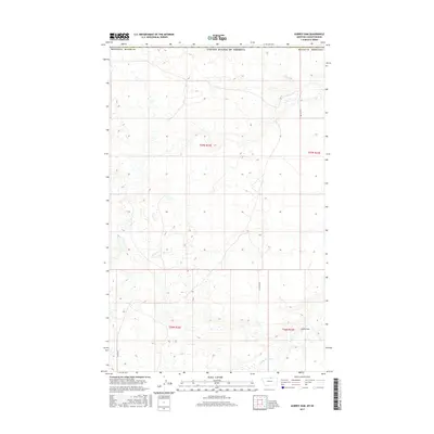
2017 Map of Aubrey Dam
USGS Topo · Published 2017About this map
Woody Island Cr meanders through the southeastern corner of this Blaine County landscape, where the prairie topography is defined by subtle drainage patterns and low-lying basins. The namesake Aubrey Dam stands as a primary landmark in the eastern reaches of the quadrangle, serving as a critical point of water management in an otherwise arid environment. This region is characterized by large-scale land divisions, where few arterial roads like Frenchy Rd and Snider Rd provide access across the expansive township sections. The map reveals a land structured by agricultural and rangeland use, where the isolation of individual water features and the grid of section lines illustrate the vastness of the northern Montana plains near the international border.
Find a feature on this map
11 named features on this map. Tap any name to fly to it.
Don’t see what you’re looking for? This feature index may not catch every label — zoom into the map to look around manually.
Map Details
Editions of this 2017 Aubrey Dam Map
This is the sole edition of this map. No revisions or reprints were ever made.
Other maps of this area

1913 · Cherry Ridge
USGS Topo · 1:125,000

1953 · Havre
USGS Topo · 1:250,000

1957 · Havre
USGS Topo · 1:250,000

1958 · Havre
USGS Topo · 1:250,000
1984 · Silver Bow Lake
USGS Topo · 1:24,000
1984 · Hogeland
USGS Topo · 1:24,000
1984 · Aubrey Dam
USGS Topo · 1:24,000
1984 · Silver Bow Spring
USGS Topo · 1:24,000
1984 · Irvins Coulee
USGS Topo · 1:24,000
1984 · Hogeland NW
USGS Topo · 1:24,000