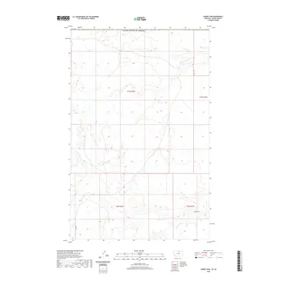
2020 Map of Aubrey Dam
USGS Topo · Published 2020About this map
Woody Island Cr meanders through the southern portion of this high plains landscape, defined by its system of reservoirs and cattle-country infrastructure. The map centers on the Aubrey Dam, a vital water management point for this arid region of Blaine County. Positioned just south of the border with the United States of America, the area is characterized by a sparse grid of rural transit lines, including Snider Rd and Frenchy Rd. The surveying of township and range lines across T37N R22E, T37N R23E, T36N R22E, and T36N R23E illustrates the organized parceling of this northern Montana territory. The landscape is dotted with numerous small wetlands and seasonal depressions, typical of the glaciated plains, which serve as essential water sources for the local livestock and wildlife in this remote frontier environment.
Find a feature on this map
9 named features on this map. Tap any name to fly to it.
Don’t see what you’re looking for? This feature index may not catch every label — zoom into the map to look around manually.
Map Details
Editions of this 2020 Aubrey Dam Map
This is the sole edition of this map. No revisions or reprints were ever made.
Other maps of this area

1913 · Cherry Ridge
USGS Topo · 1:125,000

1953 · Havre
USGS Topo · 1:250,000

1957 · Havre
USGS Topo · 1:250,000

1958 · Havre
USGS Topo · 1:250,000
1984 · Silver Bow Lake
USGS Topo · 1:24,000
1984 · Hogeland
USGS Topo · 1:24,000
1984 · Aubrey Dam
USGS Topo · 1:24,000
1984 · Silver Bow Spring
USGS Topo · 1:24,000
1984 · Irvins Coulee
USGS Topo · 1:24,000
1984 · Hogeland NW
USGS Topo · 1:24,000