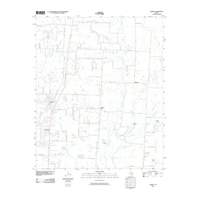
2010 Map of Aubrey
USGS Topo · Published 2010About this map
Aubrey and Krugerville serve as the primary residential anchors in this part of North Texas, situated amidst a dense network of country roads and family-named thoroughfares like McNatt Rd and Massey Rd. The landscape is defined by its complex hydrology, with the northern reaches of Lake Lewisville and numerous smaller water systems like Cantrell Slough and Running Branch shaping the land. The agricultural and rural character of the era is evident in the scattered settlements of Mustang and Spring Hill, as well as the concentration of small reservoirs such as those held by Pickens Dam and Carr Lake Dam. This 2010 survey captures a region in transition, where established farm-to-market roads intersect with emerging residential developments, all while maintaining landmarks like Pleasure Field and historic routes such as Wilson Cemetery Rd.
Find a feature on this map
56 named features on this map. Tap any name to fly to it.
Don’t see what you’re looking for? This feature index may not catch every label — zoom into the map to look around manually.
Map Details
Editions of this 2010 Aubrey Map
This is the sole edition of this map. No revisions or reprints were ever made.
Other maps of this area

1929 · Frisco
USGS Topo · 1:62,500

1954 · Sherman
USGS Topo · 1:250,000

1958 · Sherman
USGS Topo · 1:250,000

1960 · Frisco
USGS Topo · 1:24,000

1960 · Green Valley
USGS Topo · 1:24,000

1960 · Celina
USGS Topo · 1:24,000

1960 · Aubrey
USGS Topo · 1:24,000
1960 · Denton East
USGS Topo · 1:24,000
1960 · Little Elm
USGS Topo · 1:24,000

1961 · Pilot Point
USGS Topo · 1:24,000